Irlo Bronson Highway, ST CLOUD, FL 34771

Active


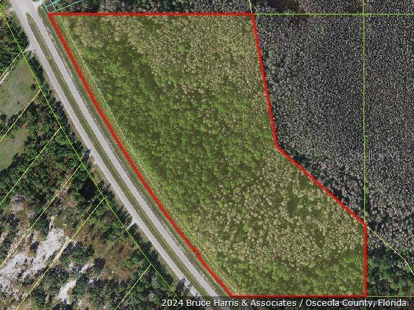
Property Photos
Would you like to sell your home before you purchase this one?
Priced at Only: $3,500,000
For more Information Call:
Address: Irlo Bronson Highway, ST CLOUD, FL 34771
Property Location and Similar Properties
- MLS#: O6300288 ( Land )
- Street Address: Irlo Bronson Highway
- Viewed: 511
- Price: $3,500,000
- Price sqft: $0
- Waterfront: No
- Year Built: Not Available
- Bldg sqft: 0
- Days On Market: 392
- Additional Information
- Geolocation: 28.1895 / -81.1502
- County: OSCEOLA
- City: ST CLOUD
- Zipcode: 34771
- Provided by: RE/MAX DOWNTOWN
- Contact: Jeff Koch
- 407-770-2050

- DMCA Notice
-
Description"Unlock the Potential of This Vacant Land!" MOTIVATED SELLER! 36 acres with over 1700 feet of frontage directly on E Irlo Bronson Highway, The entire property falls within Osceola County's designated "FUTURE LAND USE" area and is the eastern most property to have this designation. Public water and sewer are connected to the property directly to the west (Adams Homes). Of the 36 acres, 16 18 are now considered dry and ready to be developed while the remaining acres will need to be mitigated. The dry acres are the area that fronts E Irlo Bronson Highway and would make a attractive entrance to your development. Don't let this one get away! Owner is ready to sell.
Payment Calculator
- Principal & Interest -
- Property Tax $
- Home Insurance $
- HOA Fees $
- Monthly -
For a Fast & FREE Mortgage Pre-Approval Apply Now
Features
Building and Construction
- Covered Spaces: 0.00
- Fencing: Other, Wire
- Living Area: 0.00
Land Information
- Lot Features: In County, Irregular Lot, May Need To be Filled
Garage and Parking
- Garage Spaces: 0.00
- Open Parking Spaces: 0.00
Eco-Communities
- Water Source: Public
Utilities
- Carport Spaces: 0.00
- Road Frontage Type: Main Throrughfare, State Road
- Sewer: Public Sewer
- Utilities: Electrical Nearby, Sewer Nearby, Telephone Nearby, Water Nearby
Finance and Tax Information
- Home Owners Association Fee: 0.00
- Insurance Expense: 0.00
- Net Operating Income: 0.00
- Other Expense: 0.00
- Tax Year: 2024
Other Features
- Country: US
- Current Use: Highway Frontage
- Legal Description: COM AT S 1/4 COR OF 32-26-32, S89-52-36E 1021.94 FT TO POB; N27-03-43W 2.60 FT, N67-48-59E 1046.14 FT, S10-35-37E 1102.46 FT, S48-36-34E 879.70 FT, S30-50-07E 217.93 FT TO NON-TAN CURVE, CONC NE, RAD 5696.65 FT, CENT ANG 03 DEG, (CH BEARING N39-58-11 W 270.32 FT), NWLY ALONG CURVE 270.35 FT, N51-22-39E 10 FT, N38-24-22W 42.96 FT, S51-48-37W 10 FT TO NON-TAN CURVE, CONC NE, RAD 5696.65 FT, CENT ANG 11 DEG, (CH BEARING N32-36-49W 1104.59 FT), N27-03-43W 318.77 FT TO POB LYING WITHIN 05-27-32
- Area Major: 34771 - St Cloud (Magnolia Square)
- Parcel Number: 05-27-32-0000-1111-0000
- Possession: Close Of Escrow
- Views: 511
- Zoning Code: OAC
Nearby Subdivisions
Bay Lake Ranch
Country Meadow North
East Lake Reserve At Narcoosse
Florida Agricultural Co
Florida Agricultural Company
Lake Ajay Village
Lizzie Ridge
Millers Grove 1
New Eden On Lakes
New Eden On The Lakes
Oakwood Shores
Pine Grove Park
Runnymede North Half Town Of
Runnymede Ranchlands
Shelter Cove
Suburban Estates
Tops Terrace
Whip O Will Hill

- Natalie Gorse, REALTOR ®
- Tropic Shores Realty
- Office: 352.684.7371
- Mobile: 352.584.7611
- Mobile: 352.799.3239
- nataliegorse352@gmail.com